The Bottom of the North Sea Reveals Its Secrets
The North Sea is not an open book: its past lies buried under the sand of the seabed, inaccessible to most. In recent years, however, knowledge about this terra incognita has gained momentum. Dive below the water’s surface to Doggerland, Testerep, and Paardenmarkt.
For a long time, our knowledge of the seabed depended on chance discoveries, but today technology allows us to meticulously scan the bottom, enabling us to look through the sand and water mantle in detail. We see a multitude of cables and pipelines. Hundreds of wrecks from ships that perished in storms or during the turmoil of the two world wars. Abandoned munition dumps.
The North Sea has been more ‘non-sea’ than ‘sea’
At the same time, there is renewed interest in the North Sea. The realisation dawns that this submerged piece of continent only recently (about eight thousand years ago) assumed its current form, and that throughout history, the North Sea has been more ‘non-sea’ than ‘sea’. Its traces – captured in and under the seabed – are downright fascinating. Remains of peninsulas, islands and drowned villages. Yes, even relics of a veritable steppe landscape from a time when the North Sea was dry and inhabited by mammoths, woolly rhinoceroses, bison, and early humans.
Doggerland, where the North Sea is now
Let’s start the story there: twenty thousand years ago, at the height of the last Ice Age. Due to the intense cold, vast amounts of ocean water were stored in ice caps on land, causing the sea level to be one hundred and twenty metres lower than it is today. With a depth rarely exceeding fifty metres – half as deep as the height of the tallest building on the Belgian coast – the southern North Sea was dry, and you could walk to England. Much later, this now submerged land would be called Doggerland (in 2021, the National Museum of Antiquities in Leiden held an extensive exhibition about it). Conditions were harsh, and only the strongest animals could survive in this frigid wilderness crisscrossed with river valleys. As it got warmer, red deer, wild boars and roe deer joined the fauna of the Pleistocene Ice Age, which, until then, mainly consisted of woolly mammoths and rhinoceroses, cave lions, reindeer and many other beautiful things.
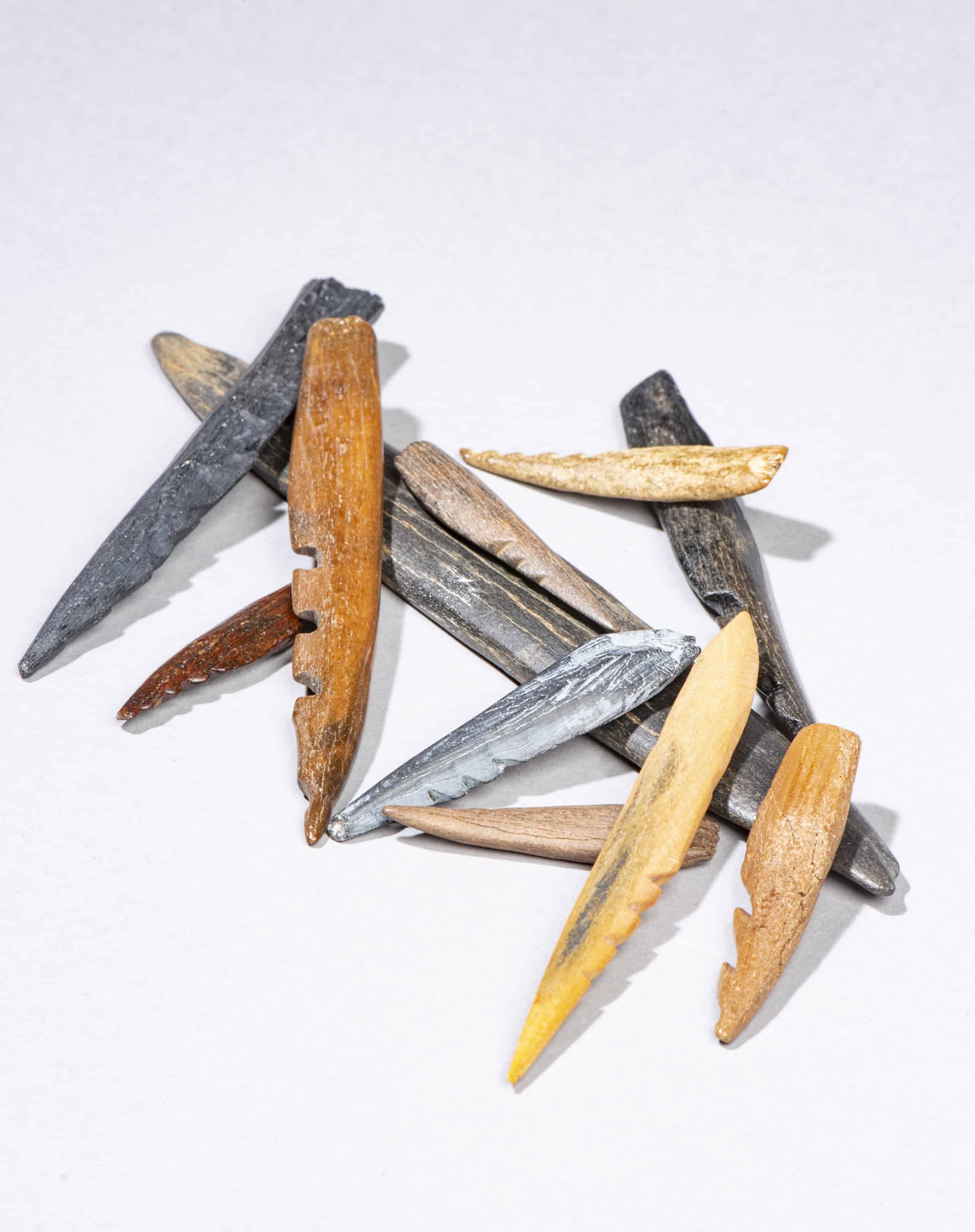 These arrowheads and spearheads are made from bone and antler and date back to the Mesolithic period, 11,000 to 8,000 years ago. They were found on the beaches of South Holland.
© National Museum of Antiquities, Leiden
The discovery of a skull fragment of a Neanderthal off the coast of Zeeland (30,000-50,000 years old) and remains and artefacts of early examples of modern humans, prove that our ancestors also felt drawn to this low-lying area during periods of low sea levels.
Extensive international research at the current Brown Ridge, an area between the Netherlands and Great Britain, where fishermen have been discovering prehistoric material for many years, confirms the presence of a peat landscape. This ten-thousand-year-old landscape has been preserved at about thirty metres below the sea surface and several metres below the seabed. By mapping and reconstructing this submerged landscape using the latest techniques, researchers hope to find possible remains or indications of human settlements and activity. This search could lead to wonderful discoveries in the coming years.
At the height of the last Ice Age the southern North Sea was dry, and you could walk to England
For the inhabitants of the time, Doggerland would not turn out to be a lasting home. Due to rising sea levels as a result of natural processes (not to be confused with the current human-driven increase), Doggerland was flooded. About seven thousand five hundred years ago, the North Sea reached our coastline again.
From a jagged to a perfectly straight coastline
The North Sea has always changed. What was once a natural, jagged coastline has been reshaped – in part due to human activity – into a perfectly straight dividing line between land and sea. Today, especially on the Belgian coast, there is hardly any evidence of a turbulent past. Nevertheless, the names of coastal towns provide plenty of hints. Koksijde, Raversijde, Ter Yde, Blutsyde: various (whether existing or vanished) place names along the Belgian coast refer to an ‘ide’ or ‘yde’, an Old Dutch term for a narrow, natural inlet widely used by fishermen to moor their boats for maintenance.
The vanished Testerep peninsula has also left its traces on etymology. Ostend, western Westende, and central Middelkerke emerged on the eastern end. Inland, until the twelfth century, there was a broad tidal creek, later reclaimed by the construction of dykes. Waves and raging storms did their best to wash away the seaward part of the peninsula. This happened, for example, with the first Ostend, which disappeared after the St. Vincent Flood in 1394. Today, researchers from the Vrije Universiteit Brussel, the Flanders Marine Institute, KU Leuven, and Howest (supported by the Research Foundation – Flanders) are studying the evolution of this natural tidal landscape over the past five thousand years. This evolution culminates in the modern-day shoreline, which is entirely shaped by human intervention. Who knows what secrets Testerep will still reveal after all these years?
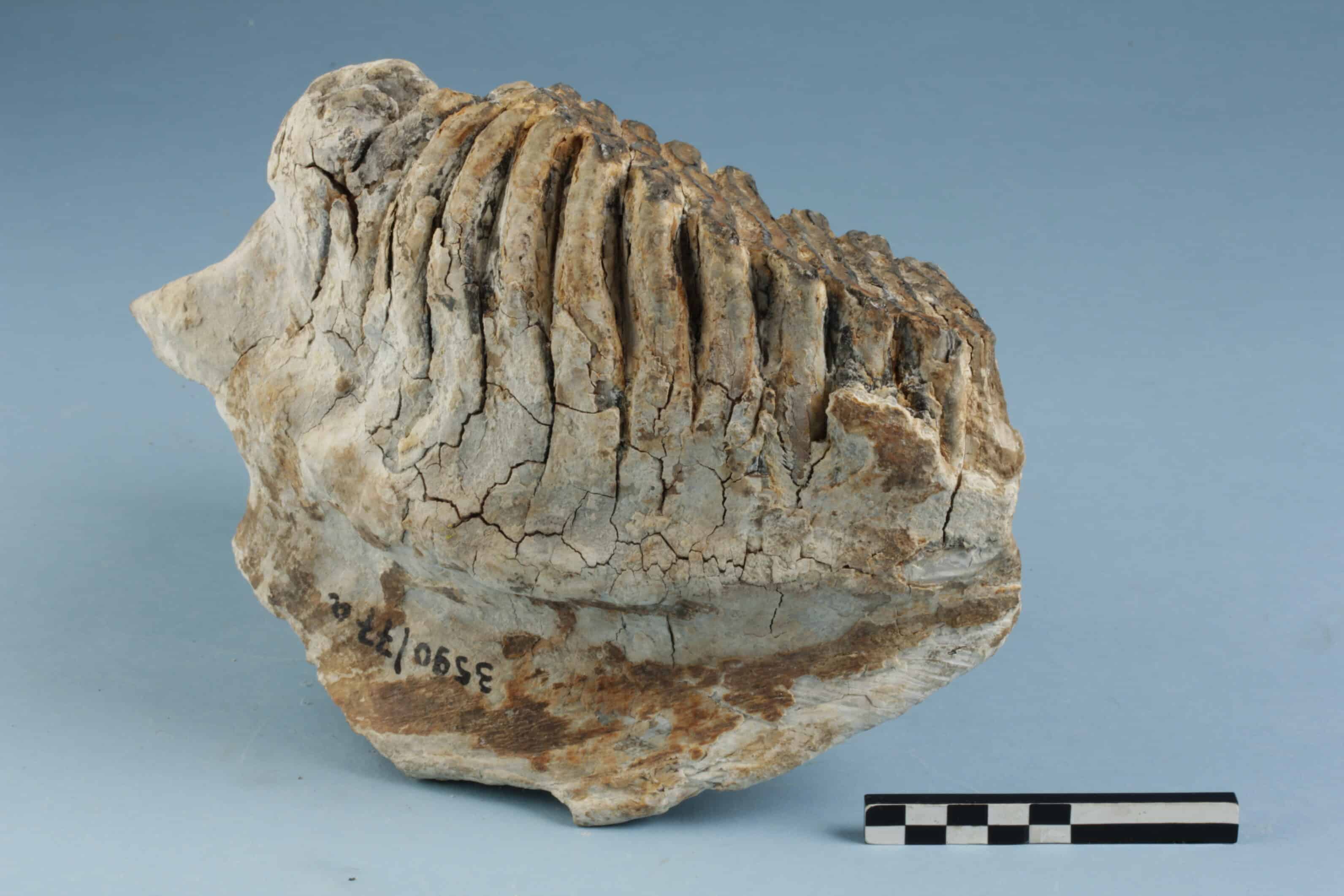 A molar from the lower jaw of a forest elephant that was fished up off the Belgian coast in the 1960s and is estimated to be between 117,000 to 130,000 years old
© Flanders Heritage Agency / Hans Denis
Wars leave their marks
The North Sea, especially its southern part leading to the Channel, has always been of particular strategic importance. This is also evident in the numerous traces left on the seabed. Over the last two millennia, hundreds of ships have perished in the North Sea due to shipwrecks and warfare. Cargo ships, passenger ships, warships, lightships, and fishing boats are just a few examples of the many types of vessels whose wrecks we find today.
All these shipwrecks are time capsules. They provide us with information about trade, shipbuilding, the transport of goods, people and ideas at a specific moment in history. The water-saturated and oxygen-poor conditions often ensure good preservation of the wreck and cargo. Therefore, in comparison to archaeological sites on land, they hold much greater informational value about the past.
Shipwrecks are time capsules providing us with information about trade, shipbuilding, the transport of goods, people and ideas at a specific moment in history
However, there are also limitations here. Our knowledge of wrecks in the North Sea is often limited to what protrudes (partly) above the seabed. These remains are relatively easy to detect using acoustic remote sensing techniques (such as multibeam and side-scan sonar). This explains why we especially know a lot about shipwreck sites dating roughly to the last hundred and fifty years.
The older wrecks, which have been eaten by shipworm (Teredo Navalis) and later largely levelled by trawling, prove to be much more challenging to locate. Their remains have sunk into the seabed and are therefore less visible. Only by chance do such sites reveal their secrets, for example, when a fisherman’s net gets caught or when they are exposed by sea activities, such as dredging or the construction of wind farms and cables.
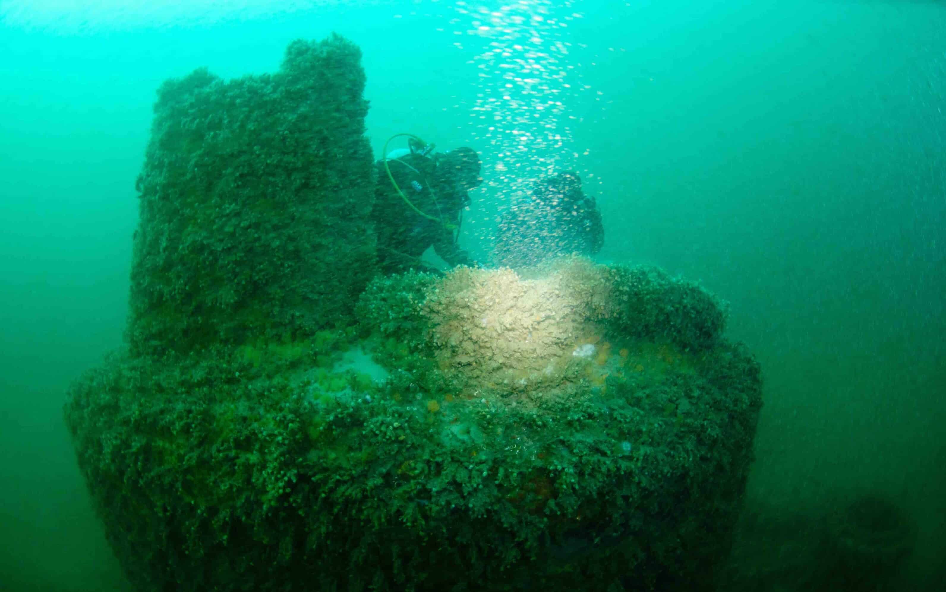 This piece of a submarine from the First World War is located on the Fairy Bank off the French-Belgian coast
© Flanders Heritage Agency / Dieter Decroos
What further complicates the investigation of wreck sites at sea is that the exact identity of these vessels is often unknown. When a ship went down with all hands, without survivors or witnesses, people ashore had no idea where or when it sank.
In such cases, wreck divers and researchers try to determine the age, origin and, ultimately, the identity of the ship based on its construction, the finds in the wreck and additional archival research. If that isn’t possible, the wrecks are often given a name referring to their location. For example, there is the eighteenth-century Buiten Ratel wreck (located on the Buiten Ratel sandbank) or the early sixteenth-century Zeebrugge wreck (found off the coast of Zeebrugge).
In addition, crew members have perished at sea in numerous shipwrecks, and their remains may still be on board. In such cases, we refer to this as a seaman’s or war grave. Besides ships, hundreds of aircraft were lost in the North Sea during the Second World War. These wreck sites are also often difficult to detect. When a plane hits the water from kilometres above and at a speed of several hundred kilometres per hour, it usually explodes. Therefore, its parts will be scattered over a large area, where they slowly become buried in sand.
Besides ships, hundreds of aircraft were lost in the North Sea during the Second World War
In recent decades, increasing attention has been given to these wrecks. There are now even laws in place to safeguard significant sites for their heritage value, taking into account factors such as age, rarity, degree of preservation and whether it is a seaman’s or war grave.
In addition to their heritage value, the larger wrecks, which still protrude above the seabed, have significant ecological importance. On this hard substrate, you often find a rich biodiversity of marine organisms, and the wreck serves as a sheltered spawning ground for many fish species. Conversely, some wrecks are more likely to pose a threat to nature due to their cargo. Today, there are still shipwrecks containing oil or other chemical substances on board, as well as warships with leaking ammunition.
A toxic dump from the First World War
Wrecks are often military materials that are unintentionally lost. Undersea munition dumps are usually the exact opposite: the material is intentionally disposed of to get rid of abandoned, dangerous bombs, grenades and other ordnance. Such munition dumps can be found in all oceans, including the North Sea. In Belgium, off the coast of Heist, there is such a dump site – the Paardenmarkt. There lies an estimated thirty-five thousand tonnes of conventional and chemical munition from the First World War buried metres deep below the seabed.
In Belgium, off the coast of Heist, there lies an estimated thirty-five thousand tonnes of conventional and chemical munition from the First World War buried metres deep below the seabed
Such munition dumps pose a potential threat to shipping and fishing, but they can also be detrimental to the marine ecosystem and possibly even to human health. Because clearing munition dumps is costly, technically challenging and not entirely without risks, it is crucial to thoroughly document and monitor such sites. Belgian scientists are trying to gain more insight into the current state of the Paardenmarkt munition dump with the DISARM project, which is essential for its risk assessment and management. In this way, the scientists hope to contribute to a global approach to dealing with these silent witnesses of a tragic chapter in our history.
Playing field for modern uses
The bottom of the North Sea not only conceals the past. Contrary to what many might think, the seabed is not a deserted, endless sand plain. On the contrary, today it serves as the setting for various economic purposes. The North Sea floor is a crucial fishing ground, hosting sought-after species like sole and plaice. Beneath the North Sea floor lie substantial oil and gas reserves that have long made a significant contribution to the energy supply and economy of several North Sea countries. Moreover, the seabed itself is also of economic importance. Significant amounts of sand and gravel are extracted annually for coastal defence works and the construction industry.
In addition to these more traditional economic sectors, the North Sea bed also plays a crucial role in the energy transition. Year after year, more wind turbines are being driven into the seabed. And through an extensive network of cables, efforts are underway to develop a European offshore electricity grid. There are even plans to utilise depleted gas reservoirs for long-term storage of CO2.
Contrary to what many might think, the seabed is not a deserted, endless sand plain
The network of cables and pipelines and the variety of economic activities that depend on the North Sea floor have become so extensive that good agreements are necessary. These have been consolidated in a marine spatial plan (MRP), which, for every human activity in the North Sea, assesses the optimal route or location, the potential competition with other economic functions, safety at sea and the ecological value of the area. Marine spatial plans are essential to ensure safety at sea and prevent damage with far-reaching consequences for people and equipment.
And what’s more: these plans are also necessary because increasingly more activities are developing at sea. More activities also mean more excavations, more preparatory studies by project developers and, ultimately, more knowledge. By working together with all those involved, a unique opportunity presents itself to further understand one of the best-preserved archaeological archives in Western Europe.
With thanks to Jan Seys and Ruth Plets for their contribution to this article.


You might also like


The Struggle to Establish Dutch as the Language of Business in Flanders


Leave a Reply
You must be logged in to post a comment.